樂活澎湖灣/奎壁山遊憩區Kueibishan Recreational Area
viewtopic.php?f=91&t=311

奎壁山地質公園 攝影:長春大飯店提供
摩西分海即時影像-北寮奎壁山 - YouTube https://www.youtube.com/watch?v=s1PuLMK36qE
位於澎湖本島東北隅的湖西鄉海邊,有一座小小的奎壁山,這裡擁有極 佳的眺望視野,除可眺望澎湖北海、東海諸島外,每當天氣狀況極佳時,還 可以看到台灣本島的山峰及麥寮六輕工業區的煙囪。
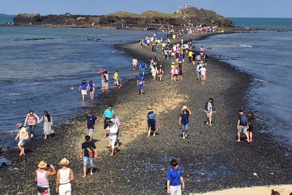
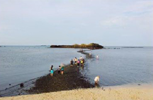
而在位於奎壁山對面不遠處的海面上,有座迷你島嶼社活A每天二次 退潮時分,一條聯結本島與赤嶼之間的海底「通道」便露出水面,海水也由 通道兩邊退去,有如「出埃及記*」中的摩西渡海時的景象。
長度約五百公尺的奎壁山海底通道純粹由卵石和沙子組成,不像澎湖其 他踏浪路線有珊瑚礁與豐富的海洋生態,所以走起來一點也不會破壞生態。 而通道兩側的潮間帶,退潮時常有當地居民在此採珠螺,遊客也可在此觀察
潮間帶生物。
想一窺奎壁山海水一剖為二景觀的遊客,可先向澎湖的旅館、釣具店或 遊客中心查詢當天的退潮時分(白天、夜晚各一次),再選擇適當的時間前 往,例如退潮退到底(干潮底)的為下午三時,大約一時抵達就可見到通道 浮出水面;來此也可走步道爬奎壁山眺望北海、東海各離島。
750公尺
*出埃及記 維基百科 http://zh.wikipedia.org/zh-tw/%E5%87%BA ... A%E8%A8%98
Kueibishan Recreation Area
Starry Kueibi of Beiliao Kueibi is one of the eight most renowned views in Penghu, and wave-chasing in Kueibishan, Beiliao, has become an important tourism resource in Penghu. The origin of the name Kueibishan: When looking at Beiliao coast from a distance, its mountain is shaped like a sea turtle bending over on the sea, therefore it was called "turtle wall mountain" (gueibishan), and later on renamed Kueibishan using its homonymic sound. In the past, on a full-moon night, when there were still many fishing boats on out the sea towards the east, basked in the soft moonlight, you would feel as if you were part of the starry sky; thus such view was named "Starry Kueibi".
湖西鄉-奎壁山遊憩區
奎壁山踏浪已然成為湖西鄉旅遊著名景點。從海上遠眺北寮山壁,極似海上巨龜,因此先民稱此地為「龜壁山」。昔日奎壁山海域在夜間布滿漁火,月色映照下宛如天上繁星閃爍,有奎壁聯輝的雅稱,也成為澎湖舊八景之一。今日奎壁山吸引遊客的則是海中踏浪步道,奎壁山海域退潮時露出S形步道通達赤嶼,沿途附近可欣賞火山岩脈、橄欖石玄武岩、海蝕溝等等地質景觀,此步道在漲潮時為海水所淹沒,退潮時才漸次裸露顯現,宛如分海露道的摩西出埃及劇情,見此景的遊客每每嘖嘖稱奇,唯獨需注意潮汐變化,需於漲潮前返回岸邊免生意外。
Mt. Kueibi is situated on the coast of Husi in the northeast corner of Penghu's main island. This location offers excellent views of the islands in the waters north and east of Penghu, and on clear days can even see the mountains on Taiwan and the chimneys of the Sixth Naphtha Cracking Plant at Mailiao.
Just off the coast is a Chihwei, a tiny island that is linked to the main island by a causeway. The causeway only appears twice a day during low tides and the sight of the seawater draining away seems like a scene out of "Exodus" when Moses parted the Red Sea.
The Kueibishan causeway measures around 500m in length and is made up of purely pebbles and sand. This sets it apart from other surf walking routes in Penghu that features corals and rich marine life, so there's no need to worry about damaging the ecology. The intertidal zone flanking the causeway is where local people often go to gather shellfish and a good place for tourists to explore the marine life as well.
Visitors interested in watching the parting of the seas at Kueibishan can check with a local hotel, fishing tackle shop or visitor center for the low tide times (once in the morning, once at night) then choose a preferred time. If low tide is 3PM, the underwater causeway should appear by about 1PM. Visitors can also climb the Kueibishan to view the islands to the north and east.
奎壁山位在澎湖北寮村北岸,俗稱「龜鼈山」,因為鄰近的海濱盛產龜鼈得而名。另有一種說法是這座山的外型從海上看,形狀像是一隻趴在海邊的烏龜而得名,就像龜山島形狀像一隻烏龜而得名一樣,可見台灣人的命名很多都是以視覺外觀來直接起名字的,直到後來,因為「龜鼈山」實在不雅,所以人們取個比較風雅的名字叫「奎壁山」,現在的名字才算固定下來。
奎壁山は澎湖北寮村の北岸に位置し、一般的には「亀鼈山」と呼ばれています。それは付近の海辺にスッポンがたくさんいることで有名になったからです。もう一つの言い伝えでは、この山の形状が海から眺めると、海辺に伏せている一匹の亀のように見えるからです。宜蘭にある亀山島の形状が一匹の亀と似ていることから名付けられたのと同様に、台湾の人々は視覚や外観から直接名称を付ける習慣があったことが分かります。後に「亀鼈山」はやや上品さに欠ける名称なので、「奎壁山」と名づけられました。現在はこの名称が定着しています。
奎壁山地質公園は奎壁山と赤嶼が含まれており、干潮の時に現れる一本の長い砂の道が二つの島を繋いでいます。典型的な陸続きの地形で、干潮の時には赤嶼まで歩いて行くことができます。とても珍しい現象で、干潮の時に現れます。ただし、前もって皆さんに言っておかなければならないことがあります。もしこの砂の道を渡るならば、必ず干潮と満潮のちょうど良い時間を計算しなければなりません。満潮時、海水は見えない赤嶼の後ろから徐々に上がって来て、一定のレベルまで達したら、赤嶼の両サイドから挟み撃ちで攻めて来るからです。人間の両足は海水がひざ以上に覆いかぶさると、海水の圧力の関係で、歩行する速度がいつもと比べて四倍から五倍ぐらい遅くなり、海水が満潮になったのに気づいたときには、もはやそこから離れられない状態となってしまいます。たくさんの観光客や地元の人たちが干満の特性を知らなかったために離れられなくなって、命を落としてしまったことがありました。それゆえ、正確に干満の時間を計算するほか、海水の特性を良く知っている地元の専門ガイドに案内してもらうことをおすすめします。
奎壁山地質公園はオリーブ石の玄武岩「番仔石」と海蝕地形が数多く見られます。これが当地質公園の重要な地質特色です。昔から奎壁山は「奎壁聯暉」という名で、澎湖八景の一つとして数えられていました。
ここを訪れたら、観光客は海ではしゃぐ以外に、遠くの風景を眺めて、果てしなく広い海を見ることができます。また、ここは星空観察と日の出観賞に適したスポットです。このほか、海に面して赤嶼右側を注意して見ると、中屯風力発電所の三基のきれいな風車が見えます。とても優雅な雰囲気なので、興味のある方は近づいて、風車をバックに写真を撮るのもよいでしょう。


奎壁山遊憩區Kueibishan Recreational Area
奎壁山自古就以「奎壁聯輝」之名被列為澎湖八景之一。奎壁山與東側另一小島"赤嶼"間,有一條長約500公尺的玄武岩步道,在退潮時會裸露出來,此時前往撿拾螺貝,觀察豐富的潮間帶生態,或是攀登赤嶼,均十分有趣。奎壁山與赤嶼一帶玄武岩地形發達,目前已列為澎湖先期規劃的六大玄武岩地質公園之一。
"Weaving Light on Kueibishan" has been one of the eight wonders in Penghu since ancient times. There's a 500-meter-long basalt front between Kueibishan and eastward Chih Islet. If you can take a stroll there on the ebb, it's fun to pick seashells, observe tidal flats' ecology, or climb up to Chih Islet. The dense basalt terrain nearby is listed as one of the six basalt geoparks in the earlier construction plan of Penghu.
Kuibishan Geopark
Located in the north shore of Beiliao Village, Penghu, Kuibi Mountain is commonly known as “Turtle Mountain”, because the close seashores were rich in turtles. Another possible reason for its name is that the mountain looks like a turtle lying on the beach if viewed from the sea, hence the name, just like Turtle Island is named for its turtle shape. It can be found that Taiwanese would like to give name to places directly based on the visual appearance. Later, because the "Turtle Mountain" is indecent, people gave it a more artistic name called "Kuibi Mountain", which is now generally accepted.
Kuibishan Geopark contains Kuibi Mountain and Chi Island. When the tide is going out, there will show a long beach land, of the terrain of land-tied island. People can walk to the Chi Island when the tide is going, and it is a very strange that this usually appear in the low tide time. However, I must remind you! If you want to go along this beach land, you must accurately calculate the low tide time, because in the high tide, the sea will rose slowly from behind the Chi Island where your eyesight can not reach, and the sea water will attack from both sides of the Chi Island. When the sea water covered high up to the knee, due to the water pressure, the walking speed will be four or five times lower than the usual days. It is often too later to leave after you see the high tide. In the past, there were many tourists or even locals who had no time to leave because they are not familiar with the characteristics of sea tides and were unfortunately killed! So, besides accurately calculating the hours of high and low tides, it is also very important to have professional tour guides who are familiar with the features of local sea water!
In Kuibishan Geopark, the basalt rich in olive stone - Fantzu stone and marine abrasion topography, is a very important geological feature of this geological park. From of old, Kuibi Mountain has been ranked one of the famous old scenery in Penghu for “Starry Kuibi”.
Here, you can not only see tourists swimming and frolicking in the sea, overlook the scenery, and see the vast ocean, but also you can watch the stars and watch the sunrise, both being suitable sceneries. In addition, on the right in front the Chi Island, with a little notice, you can see the beautiful clover windmills in Jhungtun Wind Power Farm, which are quite elegant. Interested friends can go close, for it must be fun to take photos against the windmills as background.
北寮奎壁山的「奎壁聯輝」是澎湖八景之一,北寮奎壁山踏浪成為澎湖重要觀光資源之一。奎壁山地名的由來:自海上眺望奎璧山海岸時,發現山壁走向極似一隻趴臥於海上的海龜,故稱此地為「龜鼈山」,爾後取諧音為奎壁山。以前只要月圓的晚上,奎壁山以東海面上布滿小島與漁火,加以月色映照,美景宛如天上繁星閃爍,故有奎壁聯輝的雅稱。然而現在海上布滿漁火的美景已不可得,奎壁山主要吸引遊客的是踏浪步道。
適合遊玩時間:
每日乾潮前後一個小時適合前往奎壁山海域踏浪,沿著玄武岩步道步行至離海岸300公尺遠的赤嶼。
夏日可於5時天亮以前來到奎壁山等待日出盛景,若剛好遇到退潮,則可登赤嶼欣賞日出。
月圓之夜可至奎壁山海域欣賞海上諸島與漁火在月色下點綴的澎湖東海夜色,或許可以揣摩出「奎壁聯輝」這澎湖古八景的韻味。
資料來源:沿著菊島旅行
2010-最新玩家秘笈:
奎壁山眺望海面上,有著大小雞善嶼、錠金勾嶼等島嶼陪襯,也是觀賞日出的理想地點,若遇退潮,則可登赤嶼欣賞日出。月圓之夜可至奎 壁山欣賞海上漁火在月色下點綴的澎湖東海夜色。請注意,出發前應 確時掌握當地潮汐的時間表。
 用心看台灣:奎壁山踏浪趣
玄武岩的熔岩在冷卻後,會隨著地形起伏形成各種方向的柱狀節理、或板狀裂理、或彎曲傾斜、或放射倒臥……等姿態萬千地貌奇景,及認識潮間帶有著豐富的生態資源,包括各式海參、各種螺貝、螃蟹蝦魚、以及各類軟珊瑚跟硬珊瑚..等生物\\n
北寮遊憩區 北寮奎壁山的「奎壁聯輝」是清朝澎湖舊八景之一,奎壁山下東側沿岸,與無人小島「赤嶼」之間,在退潮時會裸露出S形礫石步道,約300公尺長,近年成為遊客戲水生態旅遊的據點之一。
 北寮遊憩區
北寮遊憩區列入澎湖八景之一的北寮奎壁山,由於無重工業污染,蘊藏瑰奇多變的天然礁石及珊瑚礁魚類及底棲水族動物駐足停留,退潮時段,可與水中精靈共舞,了解水世界的奧妙,沿岸的沙灘上日積月累風化而成的砂礫形成一條步道,踏浪其間清風襲來恬適的感受,加上黃昏夕陽下與情人逐浪而行,更添浪漫之美,令人回味無窮。

奎壁山縮時攝影 Ma Guolin http://www.youtube.com/watch?v=-DTFRM24 ... e=youtu.be
赤嶼踏浪步道 宛如摩西劈紅海-民視新聞 http://www.youtube.com/watch?v=lZzi1dcs ... e=youtu.be
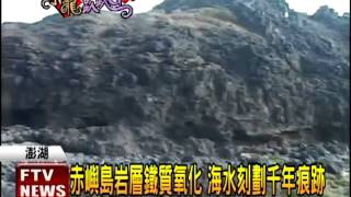
澎湖湖西鄉有一條踏浪步道很特別,北寮村和赤嶼島之間,退潮時會出現一條長約5百公尺的玄武岩步道,大海裂開的模樣,猶如摩西劈開紅海的景象,蔚為奇觀,春節假期,民眾不妨到澎湖體驗這獨特的自然美景。
"摩西分海"再現! 奎壁山奇幻步道 華視 http://www.youtube.com/watch?v=9e4QjQDO ... e=youtu.be
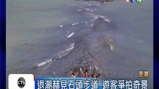
摩西將紅海分成兩半,帶領猶太人逃離埃及,是聖經裡的神蹟故事。但現在在澎湖的奎壁山,你也能看到這樣的奇景,只要算準退潮時間,就有條天然的踏浪步道會出現,讓你能走到對面的小島上。

奎壁山位在澎湖北寮村北岸,俗稱「龜鼈山」,因為鄰近的海濱盛產龜鼈得而名。另有一種說法是這座山的外型從海上看,形狀像是一隻趴在海邊的烏龜而得名,就像龜山島形狀像一隻烏龜而得名一樣,可見台灣人的命名很多都是以視覺外觀來直接起名字的,直到後來,因為「龜鼈山」實在不雅,所以人們取個比較風雅的名字叫「奎壁山」,現在的名字才算固定下來。


北寮風光除了赤嶼走海步道之外,看剛好滿潮或剛要退潮,是值得等待的。
ref:趙守忠

漲了

壺穴

風化(蕈狀石)

岩脈

擬灰岩
北寮遠眺的島嶼有:雞善嶼,錠鉤嶼....等。


